High
Latest from the National Hurricane Center:
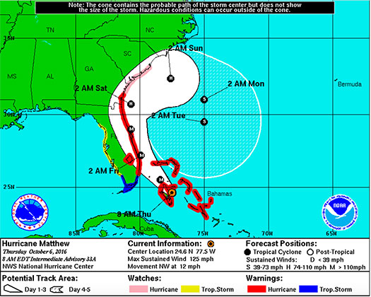
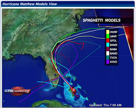
“At 500 AM EDT (0900 UTC), the center of Hurricane Matthew was located near latitude 24.2 North, longitude 77.1 West. Matthew is moving toward the northwest near 12 mph (19 km/h), and this general motion is expected to continue today. A turn toward the north-northwest is expected tonight. On the forecast track, the eye of Matthew should pass near Andros Island and New Providence in the northwestern Bahamas early this morning, then pass near Grand Bahama Island late today, and move very close to the east coast of the Florida peninsula tonight through Friday night.”
FMIT Ride-Out teams and CIRT Vendors have positioned assets inside and outside the projected path of the Hurricane and will re-direct as Matthew affects FL to maximize support capabilities.
Matthew is decreasing in pressure, which means that it is increasing in intensity even as it passes through the Bahamas. Environmental conditions appear to be favorable for further strengthening today as it has overnight and Matthew is expected to become an extremely dangerous Category 4 (130-156 mph) Hurricane moving north/northwest while it makes an unprecedented potential landfall over a large portion of eastern coastal FL.
Hurricane-force winds spread outward up to 45 miles (75km) from the center and tropical-storm-force winds spread outward up to 175 miles (280 km). The approximated lowest central pressure based on figures from the aircraft is 963 mb (28.44 inches).
FMIT Member Preparedness Actions
-
Complete any mitigation procedures prior to the storm’s arrival as safe to do so.
-
If not completed already, move or disassemble mobile or other assets susceptible to wind damage. These include: Portable & Fixed Shade Structures, Canopies, Awnings, Mobile Trash Cans, Umbrellas, Flag Poles, Tables/Benches Not Affixed to the Ground, Soccer Goals, etc…
-
Finalize the installation of any preventive instruments used to protect assets from high winds & heavy rain, such as Hurricane Shutters over windows.
-
Complete necessary preventive maintenance and vegetation removal from drains and ensure proper operation and maintenance of lift station and pump stations to minimize the influx of debris into the water and sewer management systems.
-
If utilizing the FMIT Turnkey Recovery program, please review any contracts you currently have with companies that provide emergency response products & services and contact them to notify them that they will be required to perform work under the coordination of the FMIT Turnkey Recovery program to ensure all losses and associated costs are properly managed and submitted through your insurer and FEMA for proper potential reimbursement.
-
Review Critical Assets that would be most susceptible to damage from an impending hurricane while being critical to municipal operations. Be prepared to share this list and potential mitigation procedures with Synergy/FMIT in advance of the storm. Critical Assets generally include Water Treatment Plant Assets, Critical Community Facilities, etc…
-
Ensure that any coastal assets close to the ocean (lifeguard stands, park equipment, etc…) have been moved away from potential storm surge levels.
-
Members should make sure that they have downloaded their most recent Insurance Policy from FMIT and from other Insurers.
-
Make sure that all Damage Assessment Team Members have downloaded “TrackDown – Government Edition” from the Google Play Store or the Apple iTunes Store and have logged in prior to the storm using your organization’s Username and Password.
-
Members should familiarize themselves on the steps for performing Damage Assessments using TrackDown by Clicking Here.
-
TrackDown user information is being emailed to Members and will continue into tomorrow.
-
If you have not yet received your TrackDown username and password, please email trackdown@synergyid.com to request it.
-
Members should continue to monitor the storm as well as FMIT Alerts and local/national weather forecasts.
-
Members should refer to materials from this week’s webinars available on the FMIT Alert web page by Clicking Here.
FMIT Discussion
-
Matthew remains a CAT 3 Hurricane overnight with maximum sustained winds of 125mph but is projected to become a CAT 4 Hurricane before it makes landfall in Florida.
-
Hurricane and Tropical Storm Watches and Warnings remain in Effect for Much of the East Coast of Florida.
-
The conditions between the Bahamas and Florida are favorable for Matthew to restrengthen slightly during the next couple of days. After that time, the shear is forecasted to increase, resulting in eventual weakening.
-
Matthew continues Northwest forward movement at a speed of 12mph with projections to continue moving Northwest today before it makes landfall.
-
We will continue to send updates throughout the coming days as the Hurricane starts to make impact with Florida.


